LAND PARCEL KNOWN AS “FRUTTETO”
The property identified as Frutteto is located in the northern area of Pordenone.
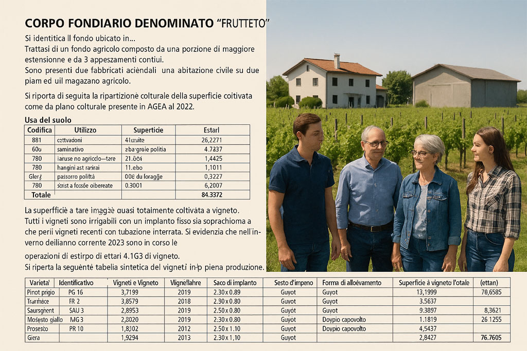
Winegrowing Estate North of Pordenone
It consists of an agricultural holding made up of a main parcel and three adjoining plots.
Two farm buildings are present on the property: a two-storey residential house and an agricultural warehouse.
Below is the breakdown of cultivated surface areas according to the cropping plan filed with AGEA (Agricultural Payments Agency) for the year 2022.
| Land Use Code | Description | Area (hectares) |
| 651 – Specialized tree crops | 410 – Wine grapevines | 76.3271 |
| 666 – Arable land | 336 – Permanent mixed meadow | 4.7637 |
| 780 – Non-agricultural use | 780 – Unproductive areas | 1.4225 |
| 780 – Unproductive areas | 789 – Field margins | 1.1011 |
| 065 – Mixed pasture | 002 – Forage | 0.5221 |
| 780 – Unproductive areas | 788 – Hedges and tree belts | 0.2007 |
| Total | 84.3372 |
The property is almost entirely cultivated with vineyards.
Unproductive areas include headlands and border zones of vineyard plots not included in the official vineyard surface recorded in Model B1, as well as internal farm roads.
Vineyard Area
The vineyard surfaces are uniform, with a predominance of recently planted vines, all in full production.
The main training system is low Guyot (modified), best suited to the low vigor of the stony soils.
All vineyards are equipped for irrigation, with fixed systems: overhead sprinklers for older vines and underground piping for the newer ones.
During the winter of 2022, 4.1639 hectares of vineyards were being uprooted.
The following summary table lists the vineyards currently in full production, based on the Model B1 vineyard surface register.
Minor discrepancies between the farm’s register and Model B1 figures are due to ongoing updates.
Only white grape varieties are cultivated.
| Variety | Vineyard ID | Vineyard Area (ha) | Year of Planting | Row × Vine Spacing (m) | Plants/Ha | Training System | Total Vineyard Area (ha) |
| Pinot Grigio | PG 15 | 4.2155 | 2013 | 2.50 × 0.96 | 4,160 | Guyot | |
| FG 23 | 5.6359 | 2008 | 2.50 × 0.86 | 5,600 | Guyot | ||
| PG 25 | 3.3872 | 2018 | 2.50 × 0.80 | 5,000 | Guyot | ||
| PG 26 | 4.9102 | 2019 | 2.50 × 0.80 | 5,000 | Guyot | ||
| PG 27 | 1.0500 | 2019 | 2.50 × 0.80 | 5,000 | Guyot | 19.1988 | |
| Traminer | TR 2 | 4.5696 | 2013 | 2.50 × 0.80 | 5,000 | Guyot | |
| TR 3 | 3.4579 | 2022 | 2.50 × 0.80 | 5,000 | Guyot | 8.0275 | |
| Sauvignon | SAU 3 | 2.2853 | 2008 | 2.50 × 0.80 | 5,000 | Guyot | |
| SAU 4 | 3.2240 | 2019 | 2.50 × 0.80 | 5,000 | Guyot | ||
| SAU 5 | 2.6600 | 2013 | 2.50 × 0.80 | 5,000 | Guyot | ||
| SAU 6 | 0.7128 | 2022 | 2.50 × 0.80 | 5,000 | Guyot | 8.8821 | |
| Moscato Giallo | MG 3 | 1.8124 | 2013 | 2.50 × 0.96 | 4,160 | Guyot | |
| MG 4 | 1.2900 | 2013 | 2.50 × 0.96 | 4,160 | Guyot | ||
| MG 5 | 3.5816 | 2019 | 2.50 × 0.96 | 4,160 | Guyot | 6.6840 | |
| Prosecco | PR 3 | 1.1303 | 2009 | 2.50 × 0.96 | 4,160 | Double arch cane | |
| PR 5 | 7.9158 | 2010 | 2.50 × 0.96 | 4,160 | Double arch cane | ||
| PR 8 | 8.4322 | 2012 | 2.50 × 1.10 | 3,636 | Double arch cane | ||
| PR 9 | 4.3637 | 2012 | 2.50 × 1.10 | 3,636 | Double arch cane | ||
| PR 10 | 3.7496 | 2012 | 2.50 × 1.10 | 3,636 | Double arch cane | ||
| PR 11 | 2.6209 | 2012 | 2.50 × 1.10 | 3,636 | Double arch cane | ||
| PR 13 | 0.9129 | 2017 | 2.50 × 1.10 | 3,636 | Double arch cane | 29.1254 | |
| Glera | PR 12 | 4.8427 | 2013 | 2.50 × 1.10 | 4,160 | Double arch cane | 4.8427 |
TOTAL VINEYARD AREA: 76.7605 hectares
Farm Buildings
On the property stand rural buildings dating back to the 1970s, consisting of an agricultural warehouse and a detached two-storey residential house.
Below is the table showing the cadastral data of the farm buildings located in the municipality of San Giorgio della Richinvelda (PN).
| Map Sheet | Plot | Sub. | Description | Category | Class | Rooms | Surface (m²) |
| 4 | 207 | 1 | A/7 – Civil residential unit | 2 | 8 | 140 | |
| 4 | 207 | 2 | C/6 – Utility building | 1 | 61 | ||
| 4 | 207 | 3 | D/10 – Rural utility building |